Directions for Following the Muir Ramble Route
WARNING!!!
The Muir Ramble Route is not yet an officially designated route. There are no trail markers for you to follow. The MRR cannot yet be walked safely from beginning to end, because there are places where the route follows roads too dangerous to safely walk on. The information and directions that follow are the result of personal observation, speculation, and information gleaned from on site observation, studying maps and the internet, including satellite photos. This information has not been reviewed or approved by any park or government officials. It reflects conditions that may change at any time without notice. The user is responsible for insuring the legality and safety of accessing the areas described along the MRR.
The trip is divided into seven separate sections.
(Click on the link below to see maps and detailed directions for following the route:)
Section One: San Francisco to Morgan Hill
Section Two: Henry Coe State Park
Section Four: San Joaquin Valley
Section Five: The Lower Foothills
Section Six: The Upper Foothills
Below you will find the following information:
1. How the directions are organized
2. Route summary by section
3. General thing you will need to know
4. Some other things to think about
How the directions are organized: This site provides the information and directions for following the 305 mile Muir Ramble Route from San Francisco to Yosemite. The MRR is divided into seven sections. Each section contains both directions for through hiking and a recommended trip that can be completed over a long weekend. For easy reference the directions are designated by mile from San Francisco.
1. Each of the seven sections begins with a summary of the route.
2. This is followed by a description of the recommended trip and alternate or side trips.
3. Next is a list of specific things you will need or need to know, like maps and accommodations.
4.
Following that is trailhead access information.
5.
Finally there are directions for following the route.
The Muir Ramble Route is varied and challenging and wonderful, an ideal urban hiking vacation for residents of the San Francisco Bay Area. Some sections of the trip are so rural that it is easy to imagine it is still 1868 and John Muir is walking right beside you. Other places are so urban that you might find yourself wishing you were back in 1868 on a little dirt road beside John Muir. The MRR is urban backpacking at its finest. Not only does it offer the opportunity to experience first hand the breathtaking changes found in Californias landscape as you travel from the bay to the Sierra, it is a sort of journey through history of California with Muir as your guide.
Route Summary:
Section one:
San Francisco to Morgan Hill. This section crosses the bay, rambles along the intermittent San Francisco Bay Trail, and then follows river corridor trails from Milpitas to Morgan Hill. The recommended trip can be done either as a two to three day bike trip, or a five to six day walk, and it encompasses the whole section. In both cases there are hotels to stay in every night, and there is one campground directly on the route.
Section two:
Henry Coe State Park. This section climbs through the wilderness of Henry Coe State Park following the Diablo Range south to Highway 152 near Pacheco Pass. The recommended trip is a 3-5 day wilderness backpacking trip that encompasses the entire section. Mountain bikes are allowed in the park, however we recommend walking to see all the wonderful native wildflowers that can make the trip so amazing to someone trying on their John Muir eyes. Camping is allowed throughout the park.
Section three:
Pacheco Pass. This section crosses the Pacheco Pass then descends through wildlife areas managed by Fish and Game into the San Joaquin Valley. The recommended trip is a long one-day trip that requires walking about a mile of busy highway so we offer two loop trips from the pass as another way to enjoy this section of the MRR. There are campgrounds at both trailheads.
Section four:
San Joaquin Valley. This section crosses the farmlands of the San Joaquin Valley from the ONeill Forebay, just west of Highway 5, to Ballico, which is just east of Highway 99. The recommended trip, which encompasses the whole section, is a two or three day bike trip that follows irrigation canals and picturesque little roads. There are campgrounds to stay in every night. There is also a recommended side trip following Muirs paddle strokes - a float down the Merced River.
Section five:
The Lower Foothills. This section traverses the lower foothills as they gently rise towards the Sierra, from Ballico to Coulterville. The entire route makes a nice two-day trip for the confident street cyclist as there are campgrounds at the beginning, end and half-way point. There are not daily lodging options for the hiker so for them the recommended trip is an 11-mile day hike on a rural ranch road that passes just east of the place Muir called Twenty Hill Hollow.
Section six:
The Upper Foothills. This section ascends the upper foothills from Coulterville to Yosemite National Park. The recommended trip follows small county roads and unpaved National Forest Service roads through the oaks and pines of the Stanislaus National Forest. The recommended trip is 35 miles and can be done either as a three-day backpack or a two-day mountain bike ride. There are unimproved campgrounds to stay in each night.
Section seven:
Yosemite. This section wanders along unimproved and little known trails through the wilds of Yosemite National Park. It begins at the Merced Grove trailhead on Highway 120 and ends at the Le Conte Memorial Lodge in Yosemite Valley. The recommended trip is a two-day wilderness backpack trip that encompasses the entire section. There is camping half way at the Tamarack Flat Campground and near the ending trailhead.
General things you will need or need to know:
When to take the trip Take your trip following the MMR in the spring: it will be too hot in the summer, too wet in the winter, and in the fall it will be hard to find water in some places. Spring is when the wildflowers are blooming, the temperatures are comfortable and the waterfalls in Yosemite are the most glorious. We suggest hiking through Henry Coe Park and the Pacheco Pass area at the height of the wildflower season, camping in the San Joaquin before the mosquitoes hatch, and walking from Crane Flat into Yosemite after the snow begins to melt, but before the Tioga Road opens.
California spring weather varies from day to day and year to year. This must be taken into account when planning your trip. It was only by chance that Muir saw all the wildflowers. If he had arrived a month earlier or later, or the winter had been drier, he may have missed the flower bloom. Some years the rains linger into late April, while in others there is still snow near Crane Flat as late as the end of June. Generally a good time to leave is mid-April, just a bit later than Muirs departure date of April 2nd.
Walk or cycle?
If Muir walked, why do we sometimes recommend cycling? When we were on our 2006 Trans California Ramble, our friend John Olmsted suggested making the trip multi-modal: Hike some places, bike others, use public transportation, and as a last recourse, when there is no other option, drive." This suggestion made a lot of sense. Muirs trip was multi-modal. He took a ferry and a train. He rode a horse from Coulterville into Yosemite Valley. But there are currently sections of the MRR that dont have lodging options in 10-15 mile intervals. Until this changes, these sections are easier to travel on a bike, where an extra five miles that would exaust a hiker, are really nothing at all.
Muir would probably approve of cycling in his honor. It is a little publicized fact, but Muir was a cyclist.
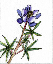
Cycling and walking are both self-powered, and therefore both green forms of transportation, but they are very different experiences. The average speed when walking is about 2-3 mph, while the average speed on a bicycle is about 8-12 mph. On a bike you will be able to cover many more miles, see much more of the California landscape in a single day than on foot. You will be able to entertain the thought of going to a campground or restaurant that is too far off the route to consider when on foot. When walking, there is time to botanize, time to experience the places you pass through, time to observe small details like the beauty of a lupine flower or follow the slimy path of a multi-colored snail crossing the trail. Both modes have their advantages and disadvantages.
General information: Shuttling: It is difficult to follow the MRR without being driven to some of the trailheads. This will change with improvements in public transportation and acquisition of right-of-ways. In some cases driving two cars is the easiest way to shuttle between trailheads. Traveling with a group of friends and one shuttle vehicle would be an even greener approach. The driver, perhaps someone who loves adventure and the outdoors but can no longer walk or cycle, may choose to join the group for part of the day but must return to the shuttle vehicle in time to get to the trails end and secure lodging, buy food, etc. for the rest of the group. The driver might want to spend the day visiting local historical sites, or studying some aspect of the regional ecology, then, as after-dinner entertainment share what they learned. If you only have a four-passenger car, but have 5 or more people, rent a passenger van with racks, or a trailer, for the bikes. Our experience is that the pleasure of having only one shuttle vehicle to drive will make it worth the extra expense. Public Transportation: Some sections of the MRR have public transportation (bus, train or taxi) options available to access the trailheads. The guide was written before Uber and so does not mention that as an option, but today makes shuttling simpler. Use these and you wont have to backtrack to get your car or worry about where to leave it. Your trip will be greener, and our experience has been that it will also be more fun. It takes planning and time to use public transportation but there can be great satisfaction in carefully cobbling together routes and schedules and thus avoid using a car! Clothes and Equipment for walking: Traveling through the wilderness is different than traveling through urban areas. In the wilderness you will need all of the standard backpacking gear, but there is no reason to be burdened with stuff like a stove, cooking pot and water filter when you are walking where you wont need it. Clothes: Pack light. Bring clothes that layer or do two jobs. For example bring lightweight synthetic zip off pants instead of heavy cotton jeans and shorts. We have found that our standard backpacking clothes work perfectly on this trip. Here is what we carried, from top to bottom: sun hat, wool stocking cap, bandanna (doubles as a towel), waterproof windbreaker, down vest, long sleeve button-down shirt, long-sleeved fleece pullover, micro fiber tee shirt, zip-off pants, two pairs of underwear, two pairs of socks, super-lightweight shoes for evenings and shoes or boots for the road. Optional clothes: rain pants, a clean shirt for evening wear and silk long underwear to sleep in. Footwear: We assumed that since we were hiking we should wear hiking boots, but the soles were too hard for pavement walking and the bottoms of our feet started to bruise after about ten miles. We learned to wear footwear appropriate for the section: hiking boots or trail-runners in the backcountry, cushioned walking or running shoes on the streets. Equipment: Bring the lightest equipment you can afford. Try to carry no more than 25 pounds without food. Our equipment list includes: a 3.5-pound two-person tent, lightweight sleeping bag (under 2 pounds if it gets cold just wear all your clothes), lightweight inflatable sleeping pad, backpacking stove, titanium pot, spoon, pocketknife, lightweight bowl (with screw on top for holding leftovers), cup, water filter (purify all water from lakes and streams), first aid kit, toothbrush and sunscreen and other toiletries. We do allow ourselves a few extras. Donna carries her watercolor paints, paper and plant identification books. I carry my ukulele and a harmonica, which I play while Donna paints. A few useful tips: We carry a short section of foam pad to sit on during the day and add under our pads at night. We use a super lightweight daypack for one of our stuff sacks, and then have a spare pack when we need it. Our cup has a screw-on lid so it can be used for rehydrating a dried dinner or used as a leftover container. Note: Make sure your water filter or water purifying tablets are rated to deal with giardia lamblia and cryptosporidium. Clothes and Equipment for cycling: Clothes: The same clothes suggested for backpacking will also work for cycling. You will need to add three things: gloves, padded bike shorts and a helmet. If you are not a regular cyclist you may not be used to wearing the padded shorts, but they are essential to cushion you on long rides. The cycling gloves will help you avoid blisters and the helmet may save your life! Equipment: Ride a mountain or hybrid bike. Some of the MRR trail surfaces are dirt or sand, with rocks and potholes, and you will need fatter tires than are on a regular street bike. Bring a tire patch kit, pump, bike light and bike lock. You may enjoy the ease of riding an electric bike as Donna did on our 2007 trip. She had no problem finding places to recharge the battery. Maps: This guidebook was written before smart phones and GPS. We still say carry maps with you at all times. GPS maps do not give you the big picture of where you are going. You will need them for general reference and especially if you have to take a detour. We recommendation what maps will be needed and where you can find them at the beginning of each section. Water and Restrooms: There are drinking fountains and restrooms along the MRR, but they are erratically spaced and not always working or open. This is a thing that we hope to see change in the future. Carry drinking water with you at all times. Accommodations: Hotels, campgrounds, private homes, community centers and churches can all provide housing for the wandering MRR traveler. Staying in hotels may be a little more expensive, but you can carry a lighter pack as you will not need much camping gear. Plan your lodging at or near the end of each days ramble, so that you can start the next day from the same place with little effort. We find shuttling from trail to lodging and back tedious, the most time consuming and anticlimactic part of the trip. When we have eliminated shuttling we have always enjoyed ourselves more. The little string of hostels we envision for the future does not yet exist, but when it does everyone will be happier. MRR etiquette - Leave No Trace: The Leave No Trace Center for Outdoor Ethics has created a set of guidelines to help minimize our impact on the places we hike and camp, and to assure that our wild places remain wild and pure for future generations. Plan Ahead and Prepare Travel and Camp on Durable Surfaces Dispose of Waste Properly Leave What You Find Minimize Campfire Impacts Respect Wildlife Be Considerate of Other Visitors Go to their website for more detailed information. www.lnt.org/main.html
Some other things to think about:
Urban Backpacking: A good half of the trip is urban backpacking. Urban backpacking routes weave through cities to find natural spots: the parks, empty land, river corridors, rural roads, bike trails and the like that are the last havens for nature. Urban backpackers often find nature on a more intimate scale, like in a patch of oak hillside, a short stretch of shoreline, or a section of river corridor. Urban backpackers dont need to carry all the gear required in the wilderness; stores, restaurants and lodging are usually close at hand, and there is always the option to call a taxi or take a bus. If you are accustomed to hiking in the Sierra, you may find urban backpacking strange at first. You wont be in remote wilderness with vast panoramic vistas of open space. Nor will you be alone in nature for days on end. Urban backpacking has its own pleasures: it provides the opportunity to discover the wilderness in your own backyard. Even in the city, the beauty of nature is inspiring. Little pockets of nature like the determined blades of grass pushing up through the sidewalk below you, the gardens and landscape plantings bringing color to the buildings and roads beside you, and the swirling, billowing clouds and the soaring birds in the sky above you, can leave you as refreshed and inspired as Muir was in his beloved Yosemite. Urban backpacking is a great group activity. One person walking through a city with a backpack may be perceived as a homeless person, and may be treated as someone to avoid or fear. When a group of people with backpacks walks through a city, it becomes a kind of movement, and people become curious, which leads to questions and the chance for education or interaction, and even the possibility of friendship or a request to join in.
Walk the Muir Ramble Route as a green vacation:
Any time you vacation by walking, cycling or using public transportation, any time you camp or stay in locally owned hotels (local eco-friendly hotels are even better!) and eat at locally owned restaurants serving locally grown food, you are taking a green vacation. That vacation might be a weekend urban backpack trip, walking out your front door and visiting the natural treasures in your own region and spending the night in local campgrounds or motels. It might be a trip using public transportation to get you and your bike to a distant starting point then enjoying the next several days ride back home again.
We have devised walking routes through our town to go shopping, to go out to dinner or just to take long walks for exercise and relaxation. We follow the railroad tracks, stroll through parks, walk along suburban streets and cut through open lots. A green vacation can be as simple as finding satisfaction by immersing yourself in nature.
The MRR is not yet completely green. Public transportation is not available to and from all the trailheads, and cars are required for shuttling in some places. But we hope one day, in the not too distant future, this will change. We hope the MRR will become a route for people to travel under their own power from the Bay Area to Yosemite, with B&Bs and hostels spaced every 10-15 miles.
Following the MRR, even as it exists today, is a good start towards taking a green vacation. You wont have to add hours of driving to a National Park destination just to begin your vacation. The California landscape will unfold at a human pace, just as it did for John Muir in 1868. You will see California in a way that is personal, historical and delightfully up close. If you want to make your next vacation greener, just walk out your front door and follow the Ramble Route to Yosemite.
Make the history come alive You are following Muirs footsteps, so as well as having the potential to be a green vacation; the MRR can be a walk through history. We give a list of history museums at the end of each section. Visit them, enjoy their displays and talk to the staff. Tell them what you are doing and talk to them about Muirs walk and California in Muirs time.
Another way to help bring the history alive is to read accounts of visits to California that were written in the 1860-70s. We suggest the following books: William Brewer's "Up and Down California" (1864) describes several of trips made through the Santa Clara Valley and the Pacheco Pass area while mapping California for the Whitney survey. In A Journal of Rambling Through the High Sierra of California (1874) Joseph Le Conte tells the story of taking Berkeley students through the Sierra with Muir as their guide. Both James M. Hutchings Scenes of Wonder and Curiosity in California and Yosemite: Its Wonders and Its Beauties (1868) by John S. Hittell, with photographs by Eadweard J. Muybridge describe how to get from Coulterville to Yosemite using the same route Muir used. John Olmsted also visited Yosemite in 1868 and wrote a book (now very rare but available on microfilm) titled: A trip to California in 1868. Another interesting work is California: for Health, Pleasure and Residence. By Charles Nordhoff (1872), and in 1876 Thompson and West published atlas maps of several counties Muir walked through.
We also recommend some more recent books including Jan Broeks The Santa Clara Valley, California: A Study in Landscape Changes (1932) Santa Clara Valley: Images of the Past (1977) by Donald DeMers, or East Bay: Then and Now (2004) by Dennis Evanosky. For the San Joaquin Valley we suggest Ghost Towns of Merced County (2005) by Herb Wood and The Road Over (2002) by the Milliken Museum Society, available from the Merced County Courthouse Museum. For the foothills and Yosemite we recommend books available through the Yosemite Association, such as Discovery of the Yosemite and the Indian War of 1851, which Led to that Event, by Lafayette H. Bunnell (1911), My First Summer in the Sierra by John Muir (1911) or for some great historical photos of the area, read Images of America: Yosemite National Park and Vicinity by Leroy Radanovich (2006).